


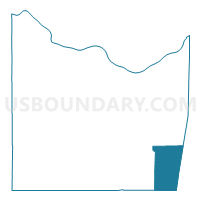
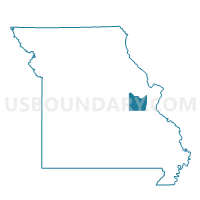
LUEBBERING Voting District, Franklin County, Missouri
About
Outline

Summary
| Unique Area Identifier | 607799 |
| Name | LUEBBERING Voting District |
| County | Franklin County |
| State | Missouri |
| Area (square miles) | 41.65 |
| Land Area (square miles) | 41.52 |
| Water Area (square miles) | 0.13 |
| % of Land Area | 99.68 |
| % of Water Area | 0.32 |
| Latitude of the Internal Point | 38.27289210 |
| Longtitude of the Internal Point | -90.81222110 |
Maps

Graphs
Select a template below for downloading or customizing gragh for LUEBBERING Voting District, Franklin County, Missouri


Neighbors
Neighoring Voting District (by Name) Neighboring Voting District on the Map
- Cedar Hill No. 1 Voting District, Jefferson County, MO
- DUEMLER Voting District, Franklin County, MO
- Fletcher Voting District, Jefferson County, MO
- Grubville No. 1 Voting District, Jefferson County, MO
- Grubville No. 2 Voting District, Jefferson County, MO
- Richwoods Voting District, Washington County, MO
- ROBERTSVILLE Voting District, Franklin County, MO
Top 10 Neighboring County Subdivision (by Population) Neighboring County Subdivision on the Map
- Meramec township, Jefferson County, MO (18,192)
- Big River township, Jefferson County, MO (6,597)
- Calvey township, Franklin County, MO (5,362)
- Prairie township, Franklin County, MO (4,034)
- Richwoods township, Washington County, MO (1,581)
Top 10 Neighboring Elementary School District (by Population) Neighboring Elementary School District on the Map
Top 10 Neighboring Unified School District (by Population) Neighboring Unified School District on the Map
- Northwest R-I School District, MO (45,694)
- Meramec Valley R-III School District, MO (22,762)
- St. Clair R-XIII School District, MO (12,448)
- Grandview R-II School District, MO (4,814)
Top 10 Neighboring State Legislative District Lower Chamber (by Population) Neighboring State Legislative District Lower Chamber on the Map
- State House District 98, MO (38,996)
- State House District 110, MO (37,588)
- State House District 105, MO (35,379)
Top 10 Neighboring State Legislative District Upper Chamber (by Population) Neighboring State Legislative District Upper Chamber on the Map
- State Senate District 26, MO (189,096)
- State Senate District 22, MO (176,515)
- State Senate District 3, MO (174,508)
Top 10 Neighboring 111th Congressional District (by Population) Neighboring 111th Congressional District on the Map
- Congressional District 9, MO (684,101)
- Congressional District 8, MO (656,894)
- Congressional District 3, MO (625,251)
Top 10 Neighboring Census Tract (by Population) Neighboring Census Tract on the Map
- Census Tract 8008, Franklin County, MO (7,649)
- Census Tract 4601, Washington County, MO (6,525)
- Census Tract 7011.02, Jefferson County, MO (5,792)
- Census Tract 4602, Washington County, MO (4,785)
- Census Tract 7004.01, Jefferson County, MO (4,746)
- Census Tract 8010, Franklin County, MO (3,758)
Top 10 Neighboring 5-Digit ZIP Code Tabulation Area (by Population) Neighboring 5-Digit ZIP Code Tabulation Area on the Map
- 63077, MO (11,798)
- 63023, MO (5,831)
- 63072, MO (3,194)
- 63060, MO (2,461)
- 63071, MO (1,103)
- 63041, MO (534)
- 63061, MO (95)